|
|
Click to enlarge
|
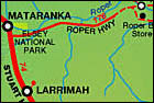
Mataranka to Borroloola Via Roper Highway and Nathan River Road Just south of Mataranka we set off to the east on the Roper Highway. This road, which is single lane bitumen nearly all the way to Roper Bar, basically parallels the mighty Roper River. The river was named by Leichardt in honor of James Roper, who was arguably the first European to see the river (on his, Roper's, birthday) when he accompanied Leichardt on his 1844-45 expedition from Brisbane to Port Essington. If you'd like to know more about this expedition, just click here and you can read actual transcripts of Leichardt's journals (chapter Xlll, Oct 19 refers to the naming of the Roper). Roper eventually settled in Merriwa NSW where he became government stock inspector in 1868. He was prominent in local affairs until his death in 1895; well outliving his expedition leader, who disappeared, presumed perished, forty-seven years earlier in 1848, whilst on a trek from Brisbane to Perth. The Roper was most certainly identified, but not named, about 200 years earlier by Abel Tasman in 1644 as he explored the coasts of the Gulf aboard his boat the Limmen; but that's another story, click here if you'd like to know more. Jilkminngan This is a spectacular drive through a region rich in the history of both aboriginal and white settlement. After the exploits of Leichardt and co, the next major influence of recent times was the construction of the Overland Telegraph Line. Only by travelling here yourself can you begin to appreciate the struggles that went into the building of what was an epic project even by today's standards. The Centenary of Federation - Connecting the Continent web site has a wealth of information about the project and area; click here to start you off (if you need QuickTime or Flash plug-ins, they are available at the bottom of the new page that will open for the link). As you pan around this tranquil scene, think about where the massive sandbank may have come from, and try to imagine the roaring torrent when the water spills over the sandbank and halfway up the trees!! (Check out the gallery for some photos I took in the big floods of wet season season 1992-93). Click here to go to a brief summary of the desperate efforts of Todd's men to overcome the wet season storms of 1871-72. Click here to see a photo gallery including Todd's merry crew assembled at the jetty in more pleasant times; the arrival of a boat with mail and supplies must have been cause for great celebration. Todd's faithful steamer, the "Omeo", an iron hulled barque of 789 tonnes and 65 metres long, is shown here at anchor in the Roper with two other supply ships; a strange site indeed some hundred and fifty kilometres from the ocean!! As you can see from the photo on the left, the remains of the "Young Australian", a wooden paddle tug of 93 tonnes, are still in the Roper River. She ran aground the following wet season (Dec 1872) travelling downstream (always difficult), on what was supposed to be anyway her last trip back to sea after the line was completed. Rumor has it that the festivities celebrating a job well done played some part!! The "Omeo" went on to provide sterling service all around the Australian coastline, and internationally, until she sank in a fierce storm in 1905 at Coogee Beach, just south of Fremantle in WA. Click here if you'd like to know a little more, plus a lovely photo of the "Omeo" under full sail. Roper
Bar The Roper Bar Store (Phone 08 8975 4636) and associated campground is the last opportunity to fuel up etc before setting off east, then south, to Limmen Bight and Borroloola. It's a popular area for people to set up for a serious fishing trip; click here for an index of current fishing reports for the NT. You can narrow your search by clicking on the Territory map in the right hand column, or expand it to any area of Australia using the drop down index below the map. Just behind where the Leichardt Memorial now stands overlooking the crossing, was Roper Bar Police Station. For decades it stood, a lonely outpost responsible for applying the law as decreed from southern capitols, over a vast area with very limited resources. The police station was washed away and rebuilt on several occasions, with floodwaters regularly rising to the eaves of the high set Queenslander style building. (Check out the gallery again for some photos I took in the big floods of wet season 1992-93). It was finally relocated about 30km away to Ngukurr in 1982, from where I can assure you it will never wash away again; the view from the police station over the river and flood plain is the stuff of tour brochures! The old station was a popular fishing base for serving and retired police until it burnt down in late 1982. There was quite some animosity at the time, but it's probably fair to say that over the many years that police had to enforce the whims of their far away masters, there were more than a few people who quite rightly felt that the law was pretty one-sided. Click here for an intriguing story about an incident on the Wilton River (which spills into the Roper just downstream from Roper Bar), and ask yourself if you would have been quite so helpful! Leaving Roper Bar, and heading east, you are in fact travelling the same route as Leichardt although in reverse, he didn't retrace his steps to get home; he took the boat from Darwin. If you want to, click here to go into his diary again and you can follow in his footsteps (bearing in mind he was travelling north – the opposite direction to this Tr@vel Guide). Along here you will pass the fairly large community of Ngukurr but it's on the north side of the river and not accessible from here. Ngukurr has a long and interesting history, first as a mission and then under local government; for some interesting information click here; PDF file. Locals tell of a large aircraft that crashed along the Roper during WW2, click here, but despite numerous sightings and expeditions it has never been positively located; perhaps you'll be the one! (Map link for Peter D) It was first thought to be the wreck of a missing B24, "Beautiful Betsy", but she turned up 2,000 miles away, in 1994 in Queensland; you'll find some background and great photos of her here. As you cruise in air conditioned comfort over the nice new bridge at the Hodgson River and on past old St Vidgeons station with its beautiful lagoon, perhaps click here and stroll a little with this lady who thought nothing of walking from here to Borroloola and paddling a canoe back! Keep an eye out about 90km east of Roper Bar; it's time to turn south and head off along the Nathan River Road for Cape Crawford/Borroloola. In addition to numerous creeks, you'll cross the tidal limits of both the Towns and the Cox rivers; all prized fishing spots. For many years the various road gangs seemed very reluctant to join this road properly from north to south; no doubt to stop the Tennant Creek gangs from venturing into the Katherine area's fishing spots and vice versa! Just north of the Cox is the turn off east which is the best way to access the bountiful waters of the famous Limmen Bight. Limmen Bight River Limmen
River Fishing Camp Maria
lagoon - Numultja Limmen
National Park Lorella Springs Bauhinia Downs Station From the Bauhinia turn off, it's only 10km south to the junction with what was the old road from the Stuart Highway to Borroloola before the Beef Road programme of the 1960's. This program, which did so much to open up the outback areas of Australia to reliable access, was probably the main impetus in opening up the Gulf area since the droving days and the construction of the Overland Telegraph Line. From this road junction you have two options; you can turn west and it's only a short 47km drive to the comforts of the Heartbreak Hotel before setting off down the bitumen to Borroloola. Alternatively you can turn east and it's an interesting, and 80km shorter, drive along the old road for 51km before joining the bitumen at Ryan's Bend for the final 26km into Borroloola. |